22 drawings · 6 sectors · LDA
Lucknow layout plans
LDA published 22 drawings covering 6 sectors of Lucknow. Every sheet here is the authority's own.
22 sheets
Aishbagh
3 sheets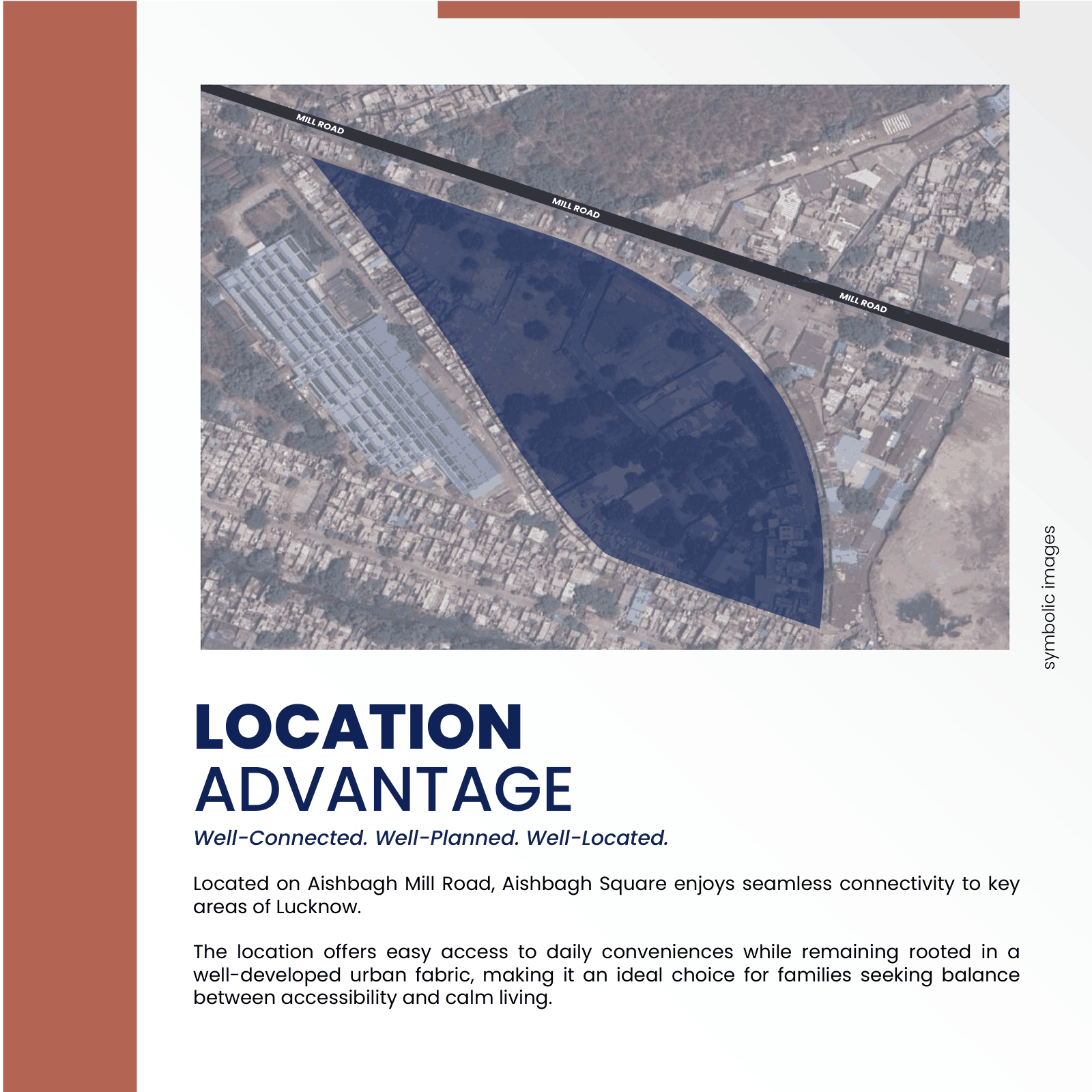 Where Aishbagh Square sits: LDA's site boundary on Mill Road, between the road and the railway line
Residential
Sheet p. 4PNG 417 KBFrom LDA's Aishbagh Square booklet, page 4.
Where Aishbagh Square sits: LDA's site boundary on Mill Road, between the road and the railway line
Residential
Sheet p. 4PNG 417 KBFrom LDA's Aishbagh Square booklet, page 4.
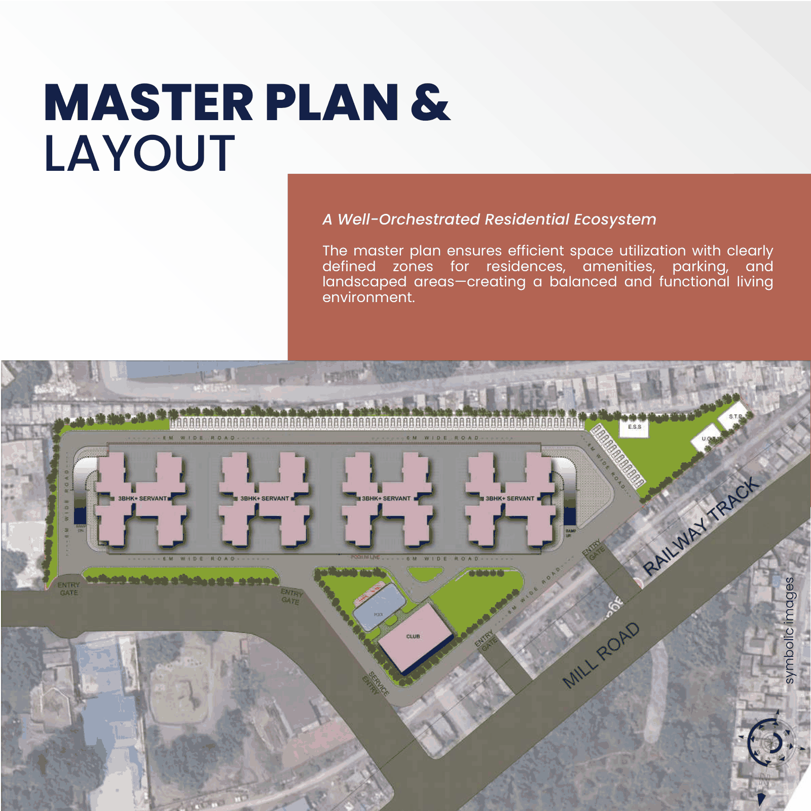 Master plan and layout: four towers, the club, the entry gates and the internal roads
Residential
Sheet p. 5PNG 358 KBFrom LDA's Aishbagh Square booklet, page 5.
Master plan and layout: four towers, the club, the entry gates and the internal roads
Residential
Sheet p. 5PNG 358 KBFrom LDA's Aishbagh Square booklet, page 5.
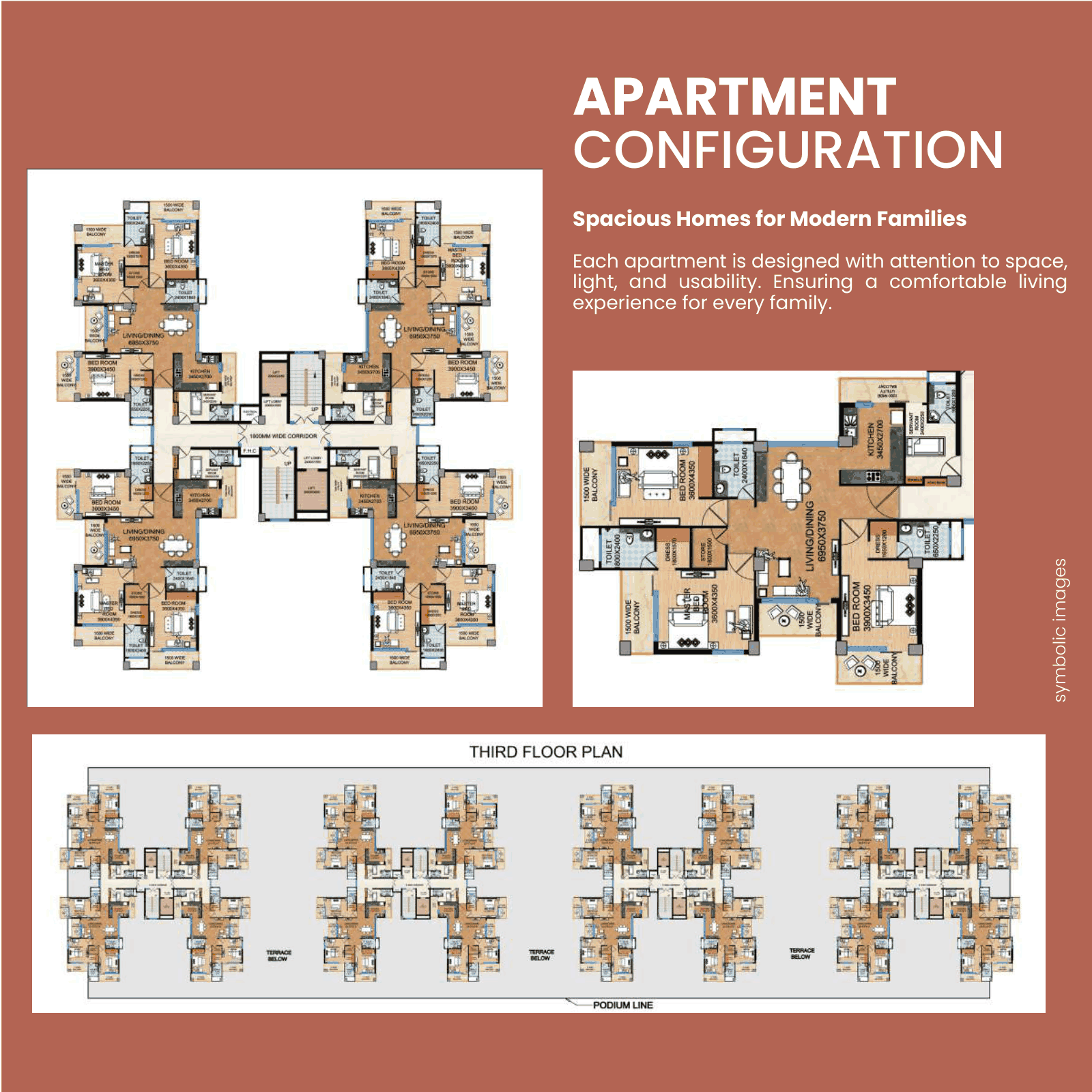 Apartment configuration: the 3BHK plus servant unit plan, the floor cluster and the third floor plan
Residential
Sheet p. 6PNG 370 KBFrom LDA's Aishbagh Square booklet, page 6.
Apartment configuration: the 3BHK plus servant unit plan, the floor cluster and the third floor plan
Residential
Sheet p. 6PNG 370 KBFrom LDA's Aishbagh Square booklet, page 6.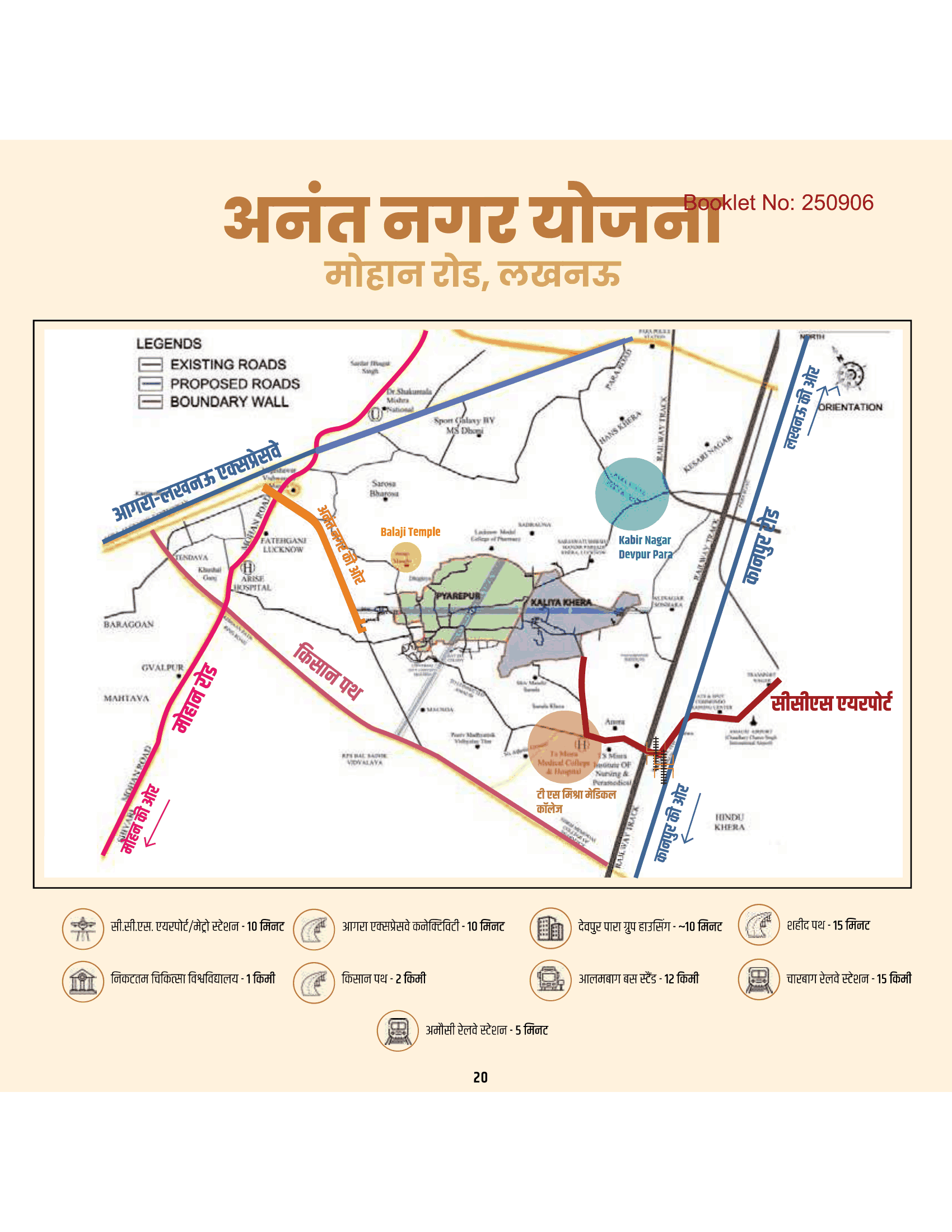 Location map, Anant Nagar Yojana, Mohan Road, Lucknow
Residential
Sheet p. 21PNG 280 KBLDA's own sheet, keyed for existing roads, proposed roads and the boundary wall.
Location map, Anant Nagar Yojana, Mohan Road, Lucknow
Residential
Sheet p. 21PNG 280 KBLDA's own sheet, keyed for existing roads, proposed roads and the boundary wall.
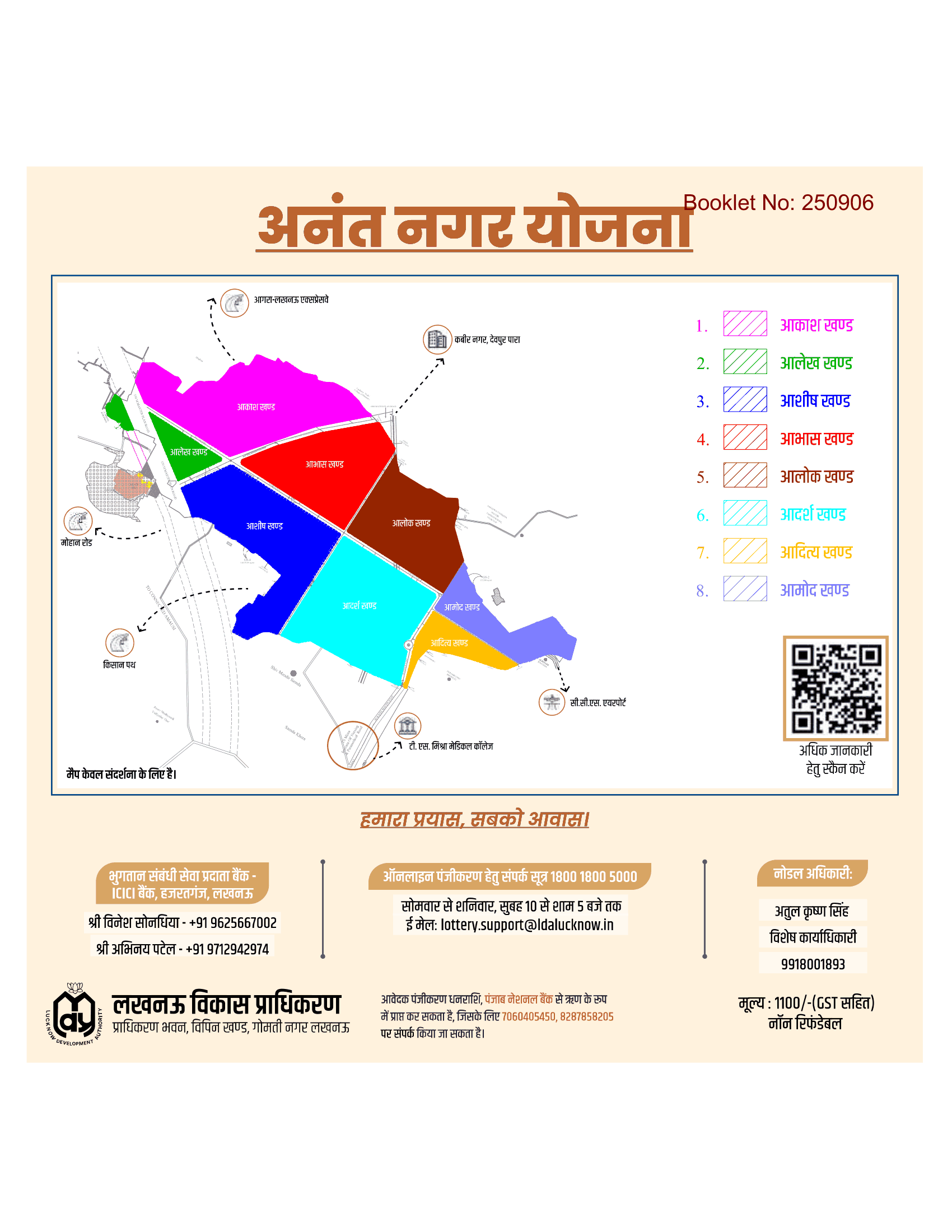 Khand plan, Anant Nagar Yojana, with Ashish Khand keyed
Residential
Sheet p. 22PNG 119 KBThe township divided into its khands, each colour-keyed. Ashish Khand is the one this scheme sells in.
Khand plan, Anant Nagar Yojana, with Ashish Khand keyed
Residential
Sheet p. 22PNG 119 KBThe township divided into its khands, each colour-keyed. Ashish Khand is the one this scheme sells in.Basant Kunj
1 sheet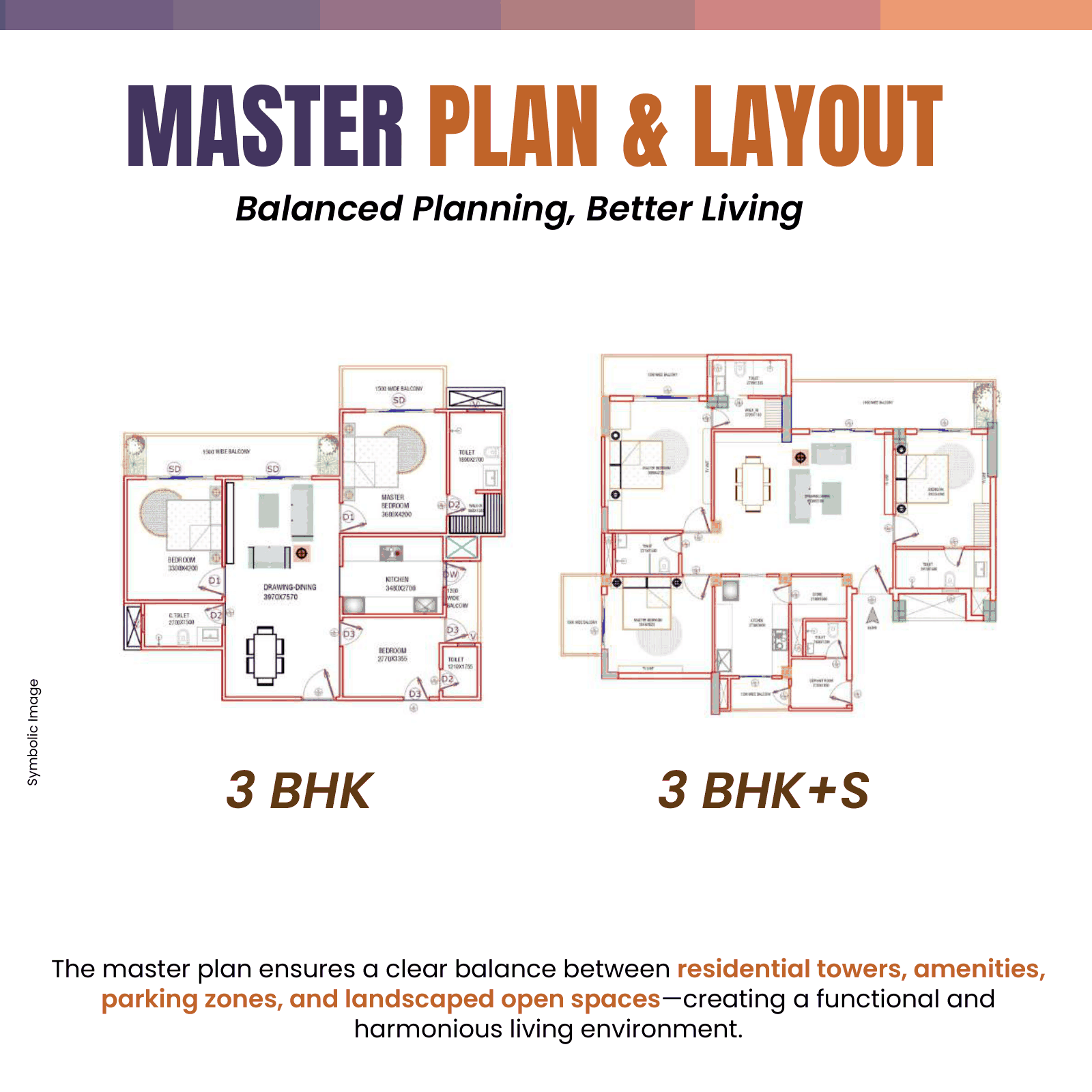
Brahma Khand
8 sheets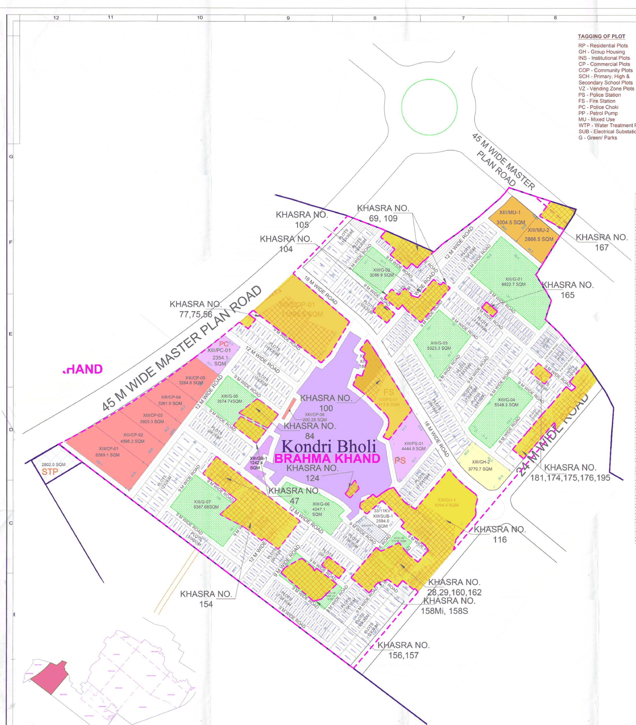 Brahma Khand as approved, plot by plot
ResidentialCommercialInstitutional
Sheet p. 1PNG 862 KBThe colony drawing itself. Every residential plot is drawn, with the 45 m master plan road on the north-west, the 24 m road on the east, and the existing abadi of Kondri Bhauli left inside the boundary. The commercial plots are the red block on the west, the parks are green, the yellow hatch is future extension.
Brahma Khand as approved, plot by plot
ResidentialCommercialInstitutional
Sheet p. 1PNG 862 KBThe colony drawing itself. Every residential plot is drawn, with the 45 m master plan road on the north-west, the 24 m road on the east, and the existing abadi of Kondri Bhauli left inside the boundary. The commercial plots are the red block on the west, the parks are green, the yellow hatch is future extension.
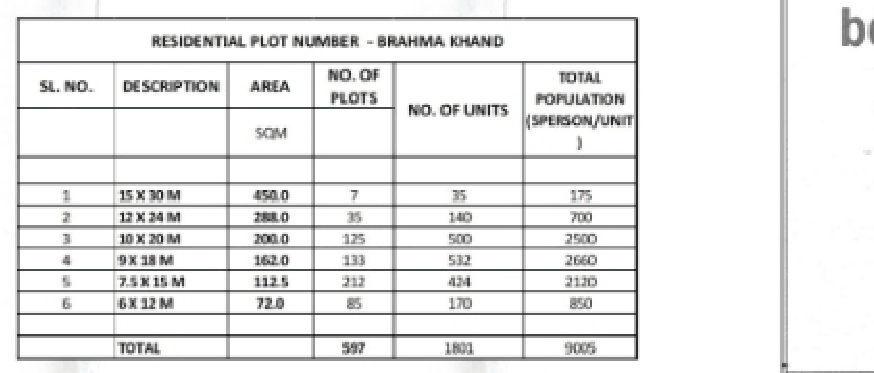 The plot schedule: 597 plots in six sizes
Residential
Sheet p. 1PNG 28 KBLDA's own RESIDENTIAL PLOT NUMBER table, which is where every row of the table on this page comes from: 7 of 15x30 m, 35 of 12x24, 125 of 10x20, 133 of 9x18, 212 of 7.5x15 and 85 of 6x12, totalling 597 plots, 1,801 units and a population of 9,005.
The plot schedule: 597 plots in six sizes
Residential
Sheet p. 1PNG 28 KBLDA's own RESIDENTIAL PLOT NUMBER table, which is where every row of the table on this page comes from: 7 of 15x30 m, 35 of 12x24, 125 of 10x20, 133 of 9x18, 212 of 7.5x15 and 85 of 6x12, totalling 597 plots, 1,801 units and a population of 9,005.
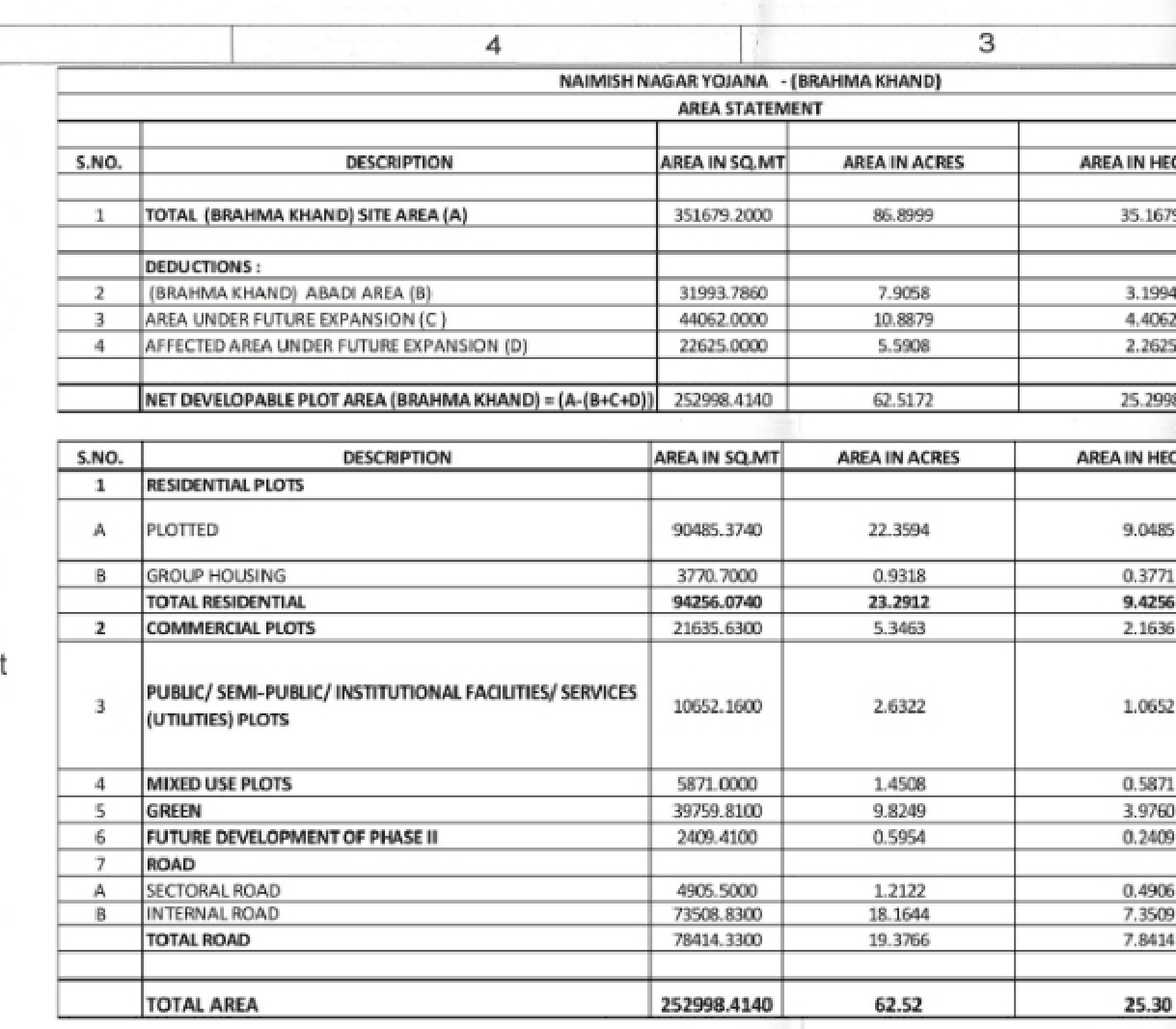 Area statement: what the 62.52 acres are used for
ResidentialCommercialInstitutional
Sheet p. 1PNG 101 KBThe khand is 351,679.2 sq m before deductions and 252,998.414 sq m - 62.52 acres - after them. Residential 37.26 per cent, road 30.99, green 15.72, commercial 8.55, public and semi-public 4.21, mixed use 2.32, phase II 0.95.
Area statement: what the 62.52 acres are used for
ResidentialCommercialInstitutional
Sheet p. 1PNG 101 KBThe khand is 351,679.2 sq m before deductions and 252,998.414 sq m - 62.52 acres - after them. Residential 37.26 per cent, road 30.99, green 15.72, commercial 8.55, public and semi-public 4.21, mixed use 2.32, phase II 0.95.
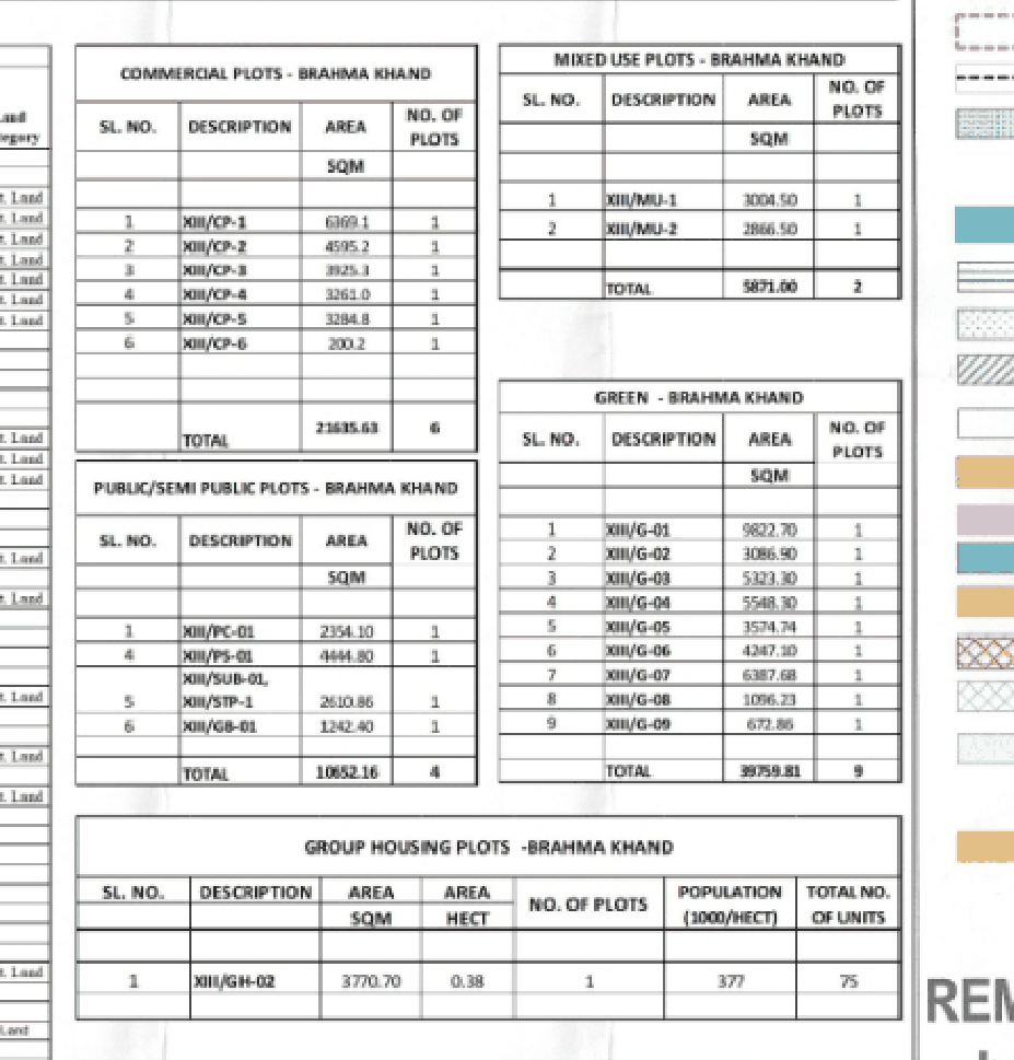 Commercial, green, public and group housing plots
CommercialInstitutional
Sheet p. 1PNG 95 KBSix commercial plots XIII/CP-01 to CP-06 totalling 21,635.63 sq m, nine parks XIII/G-01 to G-09 totalling 39,759.81, four public and semi-public plots totalling 10,652.16, two mixed use plots and one group housing plot of 3,770.70 for 75 units.
Commercial, green, public and group housing plots
CommercialInstitutional
Sheet p. 1PNG 95 KBSix commercial plots XIII/CP-01 to CP-06 totalling 21,635.63 sq m, nine parks XIII/G-01 to G-09 totalling 39,759.81, four public and semi-public plots totalling 10,652.16, two mixed use plots and one group housing plot of 3,770.70 for 75 units.
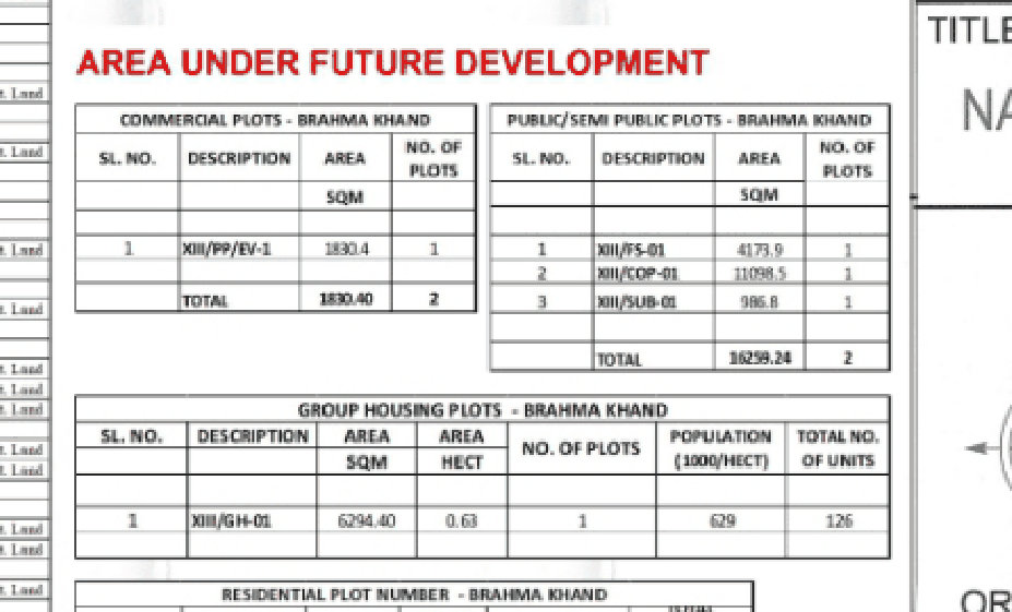 The 148 plots under future development
Residential
Sheet p. 1PNG 52 KBDrawn on the same sheet but outside the 597: 15 of 12x24 m, 16 of 10x20, 46 of 9x18, 51 of 7.5x15 and 20 of 6x12, with two commercial plots and one more group housing plot. LDA has not said when or whether these come up.
The 148 plots under future development
Residential
Sheet p. 1PNG 52 KBDrawn on the same sheet but outside the 597: 15 of 12x24 m, 16 of 10x20, 46 of 9x18, 51 of 7.5x15 and 20 of 6x12, with two commercial plots and one more group housing plot. LDA has not said when or whether these come up.
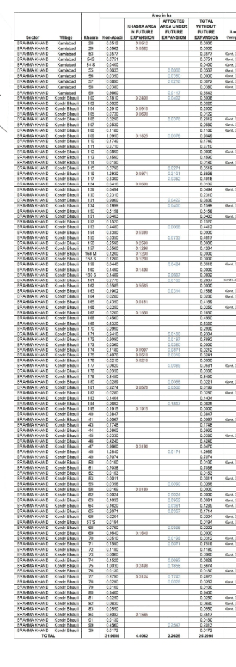 The 94 khasras this khand is built on
Residential
Sheet p. 1PNG 238 KBVillage by village and khasra by khasra, with the area of each, how much falls under future expansion, and which are government land. Kamlabad and Kondri Bhauli.
The 94 khasras this khand is built on
Residential
Sheet p. 1PNG 238 KBVillage by village and khasra by khasra, with the area of each, how much falls under future expansion, and which are government land. Kamlabad and Kondri Bhauli.
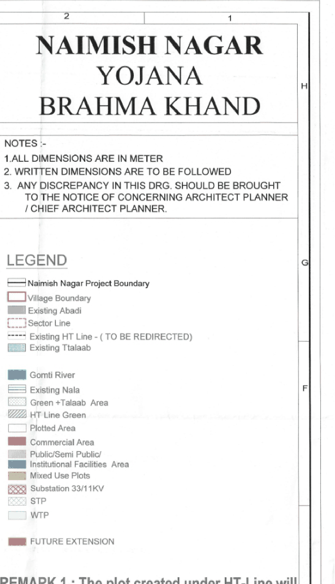 Legend, notes and the HT-line remark
Residential
Sheet p. 1PNG 169 KBThe colour key for the drawing, and LDA's own remark on it: the plots created under the HT line will be allotted only after the line is shifted.
Legend, notes and the HT-line remark
Residential
Sheet p. 1PNG 169 KBThe colour key for the drawing, and LDA's own remark on it: the plots created under the HT line will be allotted only after the line is shifted.
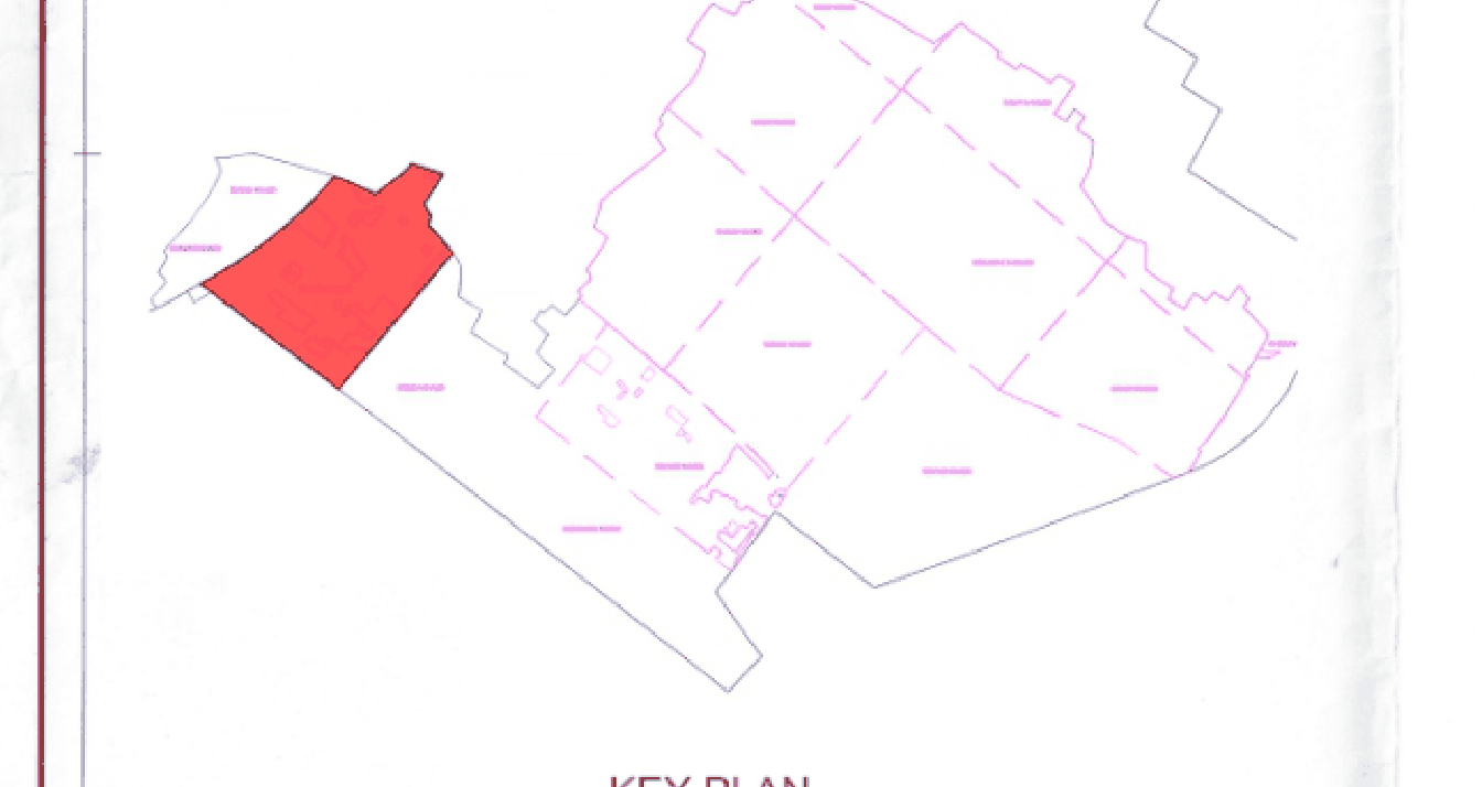 Key plan: where Brahma Khand sits in the township
Residential
Sheet p. 1PNG 74 KBBrahma Khand picked out in red against the whole of Naimish Nagar.
Key plan: where Brahma Khand sits in the township
Residential
Sheet p. 1PNG 74 KBBrahma Khand picked out in red against the whole of Naimish Nagar.Kailash Khand
6 sheets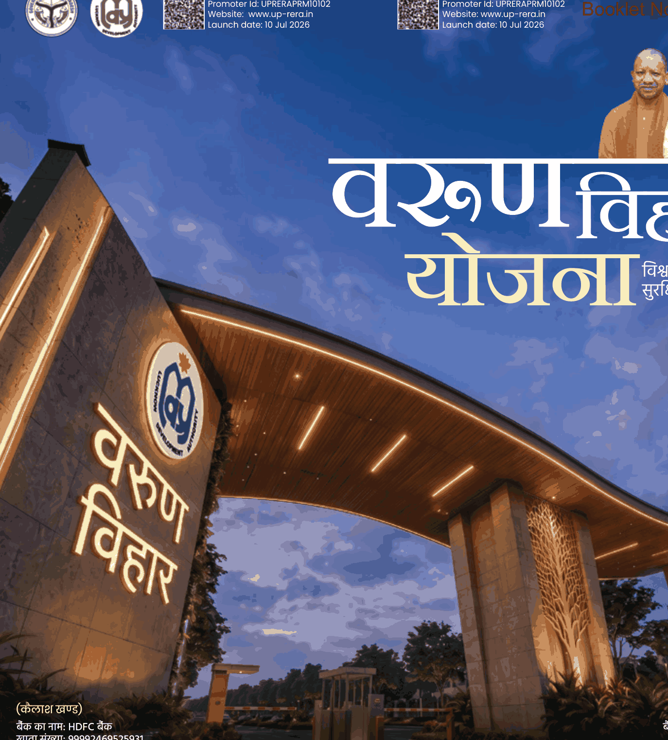 Kailash Khand as approved, plot by plot
Residential
Sheet p. 1PNG 273 KBThe colony drawing itself. Plot types A to F are marked on every plot, the 30 m road runs the length of the khand, and the yellow blocks are the 21,106 sq m marked future development inside the sector boundary.
Kailash Khand as approved, plot by plot
Residential
Sheet p. 1PNG 273 KBThe colony drawing itself. Plot types A to F are marked on every plot, the 30 m road runs the length of the khand, and the yellow blocks are the 21,106 sq m marked future development inside the sector boundary.
 The northern half, enlarged
Residential
Sheet p. 1PNG 90 KBThe upper half of the khand at twice the size: the 18 m road, the future plots along the northern edge, and the Type B and D blocks.
The northern half, enlarged
Residential
Sheet p. 1PNG 90 KBThe upper half of the khand at twice the size: the 18 m road, the future plots along the northern edge, and the Type B and D blocks.
 The southern half, enlarged
Residential
Sheet p. 1PNG 150 KBThe lower half of the khand at twice the size, along the 30 m road: the largest run of Type F plots, the substation and the 10,759.75 sq m park on the west.
The southern half, enlarged
Residential
Sheet p. 1PNG 150 KBThe lower half of the khand at twice the size, along the 30 m road: the largest run of Type F plots, the substation and the 10,759.75 sq m park on the west.
 The plot schedule and the land use: 1,218 plots in six types
ResidentialCommercial
Sheet p. 1PNG 15 KBLDA's own tables, which are where every row of the table on this page comes from: Type A 15x30 m 63 plots, B 12.5x24 39, C 12x24 30, D 10x20 183, E 9x18 144, F 7.5x15 759, totalling 1,218 plots over 194,005.5 sq m. Beside them, the sector's land use and the single 272.19 sq m convenience shop that is the whole of its commercial land.
The plot schedule and the land use: 1,218 plots in six types
ResidentialCommercial
Sheet p. 1PNG 15 KBLDA's own tables, which are where every row of the table on this page comes from: Type A 15x30 m 63 plots, B 12.5x24 39, C 12x24 30, D 10x20 183, E 9x18 144, F 7.5x15 759, totalling 1,218 plots over 194,005.5 sq m. Beside them, the sector's land use and the single 272.19 sq m convenience shop that is the whole of its commercial land.
 The 55 khasras this khand is built on
Residential
Sheet p. 1PNG 12 KBKhasra by khasra across Gahalwara and Dona, with the government land in each: 11.987 of the sector's 32.8344 hectares.
The 55 khasras this khand is built on
Residential
Sheet p. 1PNG 12 KBKhasra by khasra across Gahalwara and Dona, with the government land in each: 11.987 of the sector's 32.8344 hectares.
 Key plan: where Kailash Khand sits in Varun Vihar
Residential
Sheet p. 1PNG 69 KBKailash Khand (phase 1) picked out in red against the whole yojna and the Agra Expressway that runs along its northern edge.
Key plan: where Kailash Khand sits in Varun Vihar
Residential
Sheet p. 1PNG 69 KBKailash Khand (phase 1) picked out in red against the whole yojna and the Agra Expressway that runs along its northern edge.Varun Vihar
2 sheets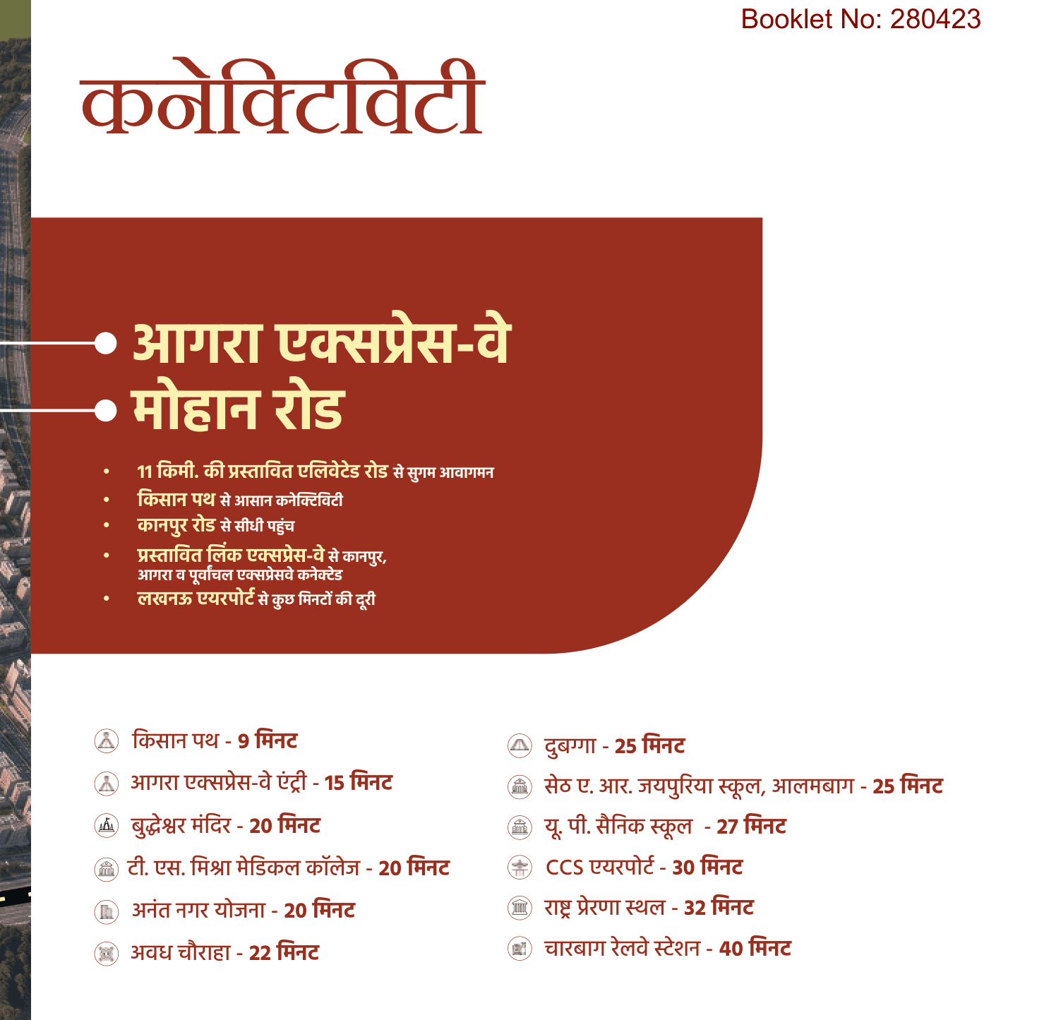 Connectivity, and LDA's own drive times
Residential
Sheet p. 21PNG 70 KBBooklet page 14. The Agra Expressway and Mohan Road, an 11 km elevated road proposed, Kisan Path and Kanpur Road, and a proposed Link Expressway to Kanpur, Agra and Purvanchal. The times are the developer's own and nobody has driven them for this page.
Connectivity, and LDA's own drive times
Residential
Sheet p. 21PNG 70 KBBooklet page 14. The Agra Expressway and Mohan Road, an 11 km elevated road proposed, Kisan Path and Kanpur Road, and a proposed Link Expressway to Kanpur, Agra and Purvanchal. The times are the developer's own and nobody has driven them for this page.
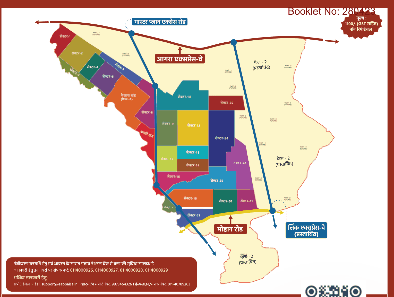 The sector map, with Phase 2 marked
Residential
Sheet p. 36PNG 52 KBThe booklet's back cover. Sectors 1 to 25 numbered, Kailash Khand and Kashi Khand marked at the western end, the Agra Expressway along the north, Mohan Road at the south and the proposed Link Expressway cutting across. The pale area to the east is marked Phase 2, proposed.
The sector map, with Phase 2 marked
Residential
Sheet p. 36PNG 52 KBThe booklet's back cover. Sectors 1 to 25 numbered, Kailash Khand and Kashi Khand marked at the western end, the Agra Expressway along the north, Mohan Road at the south and the proposed Link Expressway cutting across. The pale area to the east is marked Phase 2, proposed.Nothing on this page is ours. Each drawing is the authority's own. Where a sheet is still live on the authority's site the tile opens that file, so you are always looking at what the authority is publishing today rather than a copy we took once.